

The ridge of high pressure responsible for hot and dry weather across California will stomp out the sea breeze Thursday, and Bay Area residents can expect temperatures to climb up to 20 degrees above average for October. Without the natural A.C., Thursday will be the hottest day so far this season for San Francisco, with highs in the 90s expected at the city’s official weather station.
Daytime temperatures are expected to soar to the lower 80s on the west side and upper 80s east of Sutro Tower. There is a good chance that hot winds from the northeast will promote a few 90-degree hot spots in and around the downtown area Thursday afternoon.
Baron/Lynx
Sizzling microclimates
The National Weather Service issued a heat advisory for residents along San Francisco Bay, in the South Bay and the Santa Cruz Mountains from 11 a.m. Thursday to 11 p.m. Friday.
Dry winds and ample sunshine will allow an urban heat island effect to take hold in San Francisco’s neighborhoods east of Sutro Tower, raising temperatures past the 90-degree mark in parts of downtown. Residents closer to the Embarcadero, Presidio and North Beach can look for temperatures closer to the upper 80s.
Thursday afternoon’s temperatures will range from the upper 80s to lower 90s, with pockets of 90-degree temperatures possible west of the Oakland and Berkeley hills thanks to sunshine and dry winds.
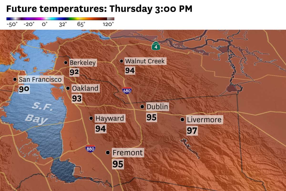
Baron/Lynx
The hottest weather in the region will be found Thursday afternoon in the East Bay. Hot winds are expected to spill into Oakland and Berkeley over the course of the day, raising temperatures to 90 by the afternoon. Inland residents in the Tri-Valley area can expect high temperatures in the lower to mid-90s.
Residents in cities like San Francisco and Oakland can expect some heat risk, where temperatures over 85 degrees don’t typically occur. This means the unusually hot weather could raise the potential for heat-related illnesses, so it’s best to avoid working outdoors and to seek shade whenever possible.
Coastal impacts
Residents planning to escape the hot weather by visiting Highway 1 beaches Thursday afternoon will find that the heat followed them to the coast. Weather models predict today’s hot and dry winds will reach Highway 1 beaches like Marshall’s, Pacifica and Mavericks. Expect plenty of sunshine and afternoon temperatures in the upper 70s to lower 80s, with a few mid-80s possible at bay shore beaches in Alameda, Albany and Sausalito.
All in all, it’s shaping up to be a scorcher along the bay shore. These conditions are expected to continue through Saturday, so stay tuned for updates to the forecast.
Thursday breakdown
San Francisco: A hot and sunny morning is on tap for San Franciscans, with temperatures climbing from the 60s at sunrise to the 80s by noon on the west side. A faint sea breeze will help keep temperatures in the mid-80s at Ocean Beach, Lake Merced and the Presidio. Residents taking Muni from West Portal to downtown can expect a sharp uptick in temperatures — to the lower 90s in Castro, the Mission, SoMa and the Tenderloin.
After sunset, expect cooler winds by the water and nighttime lows in the lower 60s. Residents in Twin Peaks and Diamond Heights will likely experience lows in the mid-60s.
East Bay: Residents taking the ferry out of Jack London Square and Alameda Island can expect a dramatic temperature swing between the morning and evening commute, with temperatures jumping from the 60s at sunrise to the upper 80s by rush hour. Sunny skies will remain over the Oakland and Berkeley hills as temperatures along the I-80 and I-880 corridors reach the upper 80s to lower 90s.
Inland residents east of the Caldecott Tunnel can look for sunshine and highs in the lower to mid-90s. Hotter temperatures in the upper 90s are possible around Danville, Livermore and Pittsburg.
Light, cool winds will slowly return in the evening. Look for nighttime lows in the mid-60s, with upper 60s likely in the foothills and around Mount Diablo.
North Bay: Hot and dry weather returns to the inland valleys. Residents in Petaluma, Napa and Santa Rosa can look for daytime highs in the lower to mid-90s. What’s left of the sea breeze will keep temperatures closer to the mid-80s in bay shore cities like Sausalito, Vallejo and San Rafael, while upper 80s set up shop at Mount Tam and in Mill Valley.
Commuters headed to Sacramento this evening can expect scorching temperatures reaching the upper 90s along the I-80 corridor east of Cordelia, including in Fairfield and Vacaville.
Expect clear skies after sunset and nighttime lows in the mid-60s by the water and upper 60s inland, along with a few lower 70s at summits in the Mayacamas and Sonoma County mountains.
Pacific Coast and Peninsula: Temperatures will approach the mid-80s along Highway 1, including in Pacifica, Half Moon Bay and Daly City. Upper 80s are on tap for residents along the San Bruno Gap and the I-280 and Highway 1 corridors this afternoon.
Cooler air returns in the evening, and nighttime temperatures are expected to fall to the mid-60s, though a few upper 60s are possible in the foothills near Redwood City and Palo Alto.
South Bay and Santa Cruz: Clear skies and dry northeast winds are expected to raise daytime temperatures to the lower to mid-90s in the Cupertino Hills and Santa Cruz Mountains. Highs in downtown San Jose and along the Highway 101 corridor between Morgan Hill and Gilroy will also surpass the 90-degree mark, with a few upper 90s possible in East San Jose and Milpitas.
The sea breeze will help moderate temperatures along Monterey Bay, but daytime highs and dry winds around Watsonville and Santa Cruz will help raise temperatures on the shore to the lower 80s, with a few mid-80s possible at beaches near Capitola and La Selva.
After sunset, expect nighttime temperatures in the mid-60s by the water and upper 60s to lower 70s inland.
Reach Gerry Díaz: gerry.diaz@sfchronicle.com; Twitter: @geravitywave


